   A boundary survey is the physical staking of property corners and/or property lines. Following the physical staking, either a corner record or record of survey is prepared by TDR and submitted to the County of Los Angeles for public record.
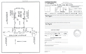 CORNER RECORD CORNER RECORDA corner record is an 8-1/2" x 11" form showing methods of establishment and monuments set. A corner record is prepared if the property's boundary lines are shown on a subdivision map, official map, or record of survey (properties which fall under this category are typically delineated with all solid lines on the county assessor's map). 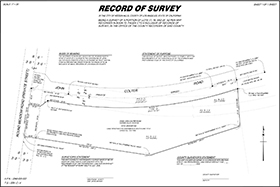 RECORD OF SURVEY RECORD OF SURVEYA record of survey is an 18" x 28" map showing methods of establishment and monuments set. A record of survey is prepared if the property's boundary lines are not shown on a subdivision map, official map, or previously filed record of survey (properties which fall under this category are typically delineated with at least one dashed line on the county assessor's map). |
| ©2025 TDR Engineering (818) 761-1508 2566 N. San Fernando Road, Los Angeles CA 90065 | 501 W. Glenoaks Blvd. #145, Glendale CA 91202 |